Blue River Watershed Facts
What is a watershed?
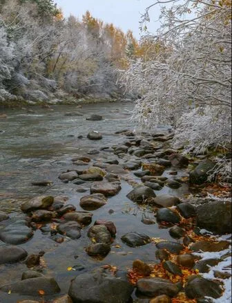
A watershed is the area of land where all precipitation, rain and snowmelt, drains to a common river or stream. In the case of the Blue River watershed, this includes the high mountain terrain surrounding Summit County as well as parts of Lake and Grand County. Water that falls anywhere in this basin flows downhill through creeks and tributaries into the Blue River, eventually joining the larger Colorado River system at the confluence near Kremmling.
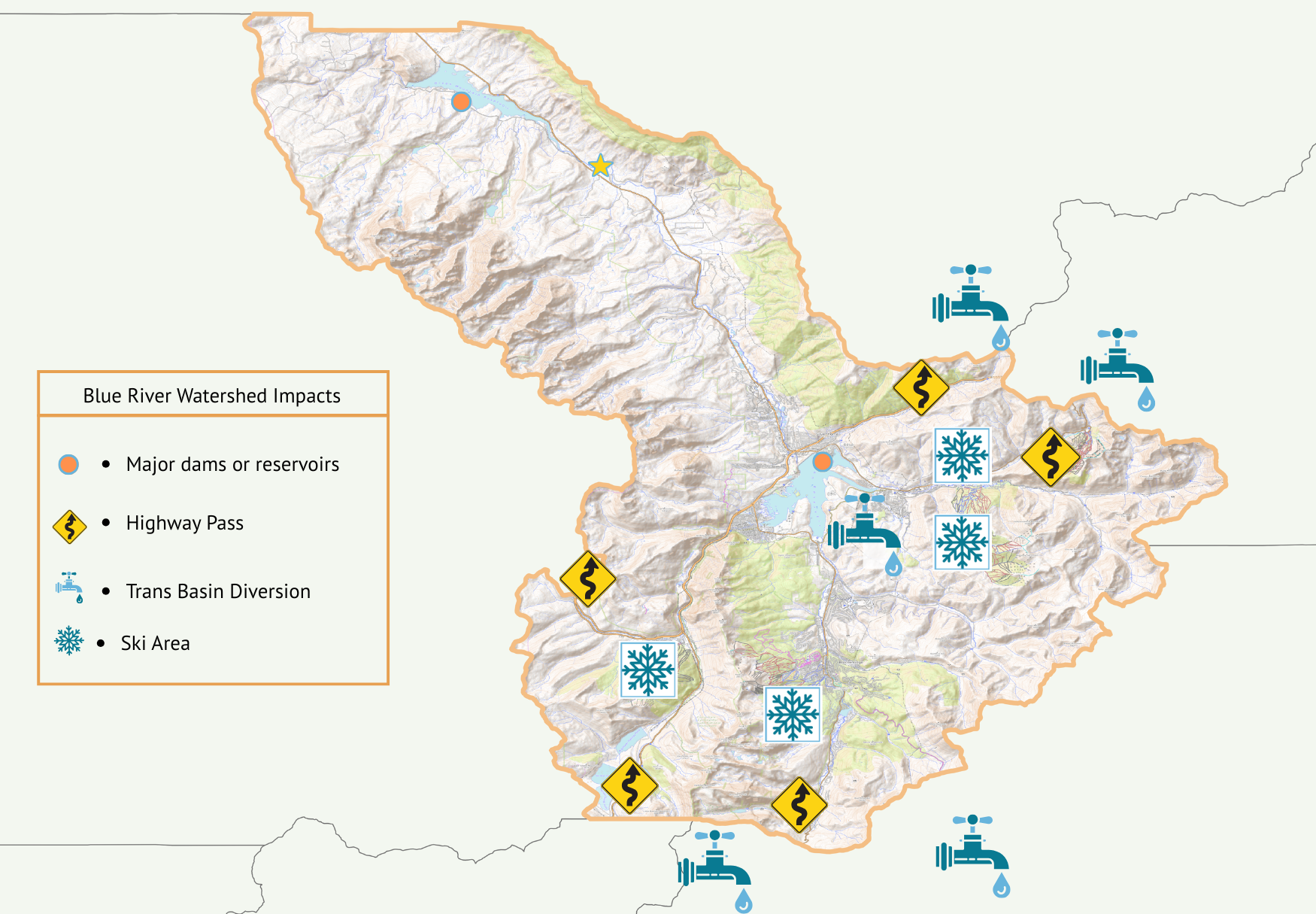
The Blue River watershed is shaped by alpine landscapes, forests, wetlands, as well as 5 transbasin diversions, 6 mountain passes, 4 ski areas, historic and current mining, 2 major reservoirs, developed communities, and agriculture all of which influence the quantity and quality of water throughout the watershed. These influences directly affect water quality, stream health, and habitat for fish and wildlife. Understanding the watershed helps guide efforts to protect clean water, support ecosystems, and sustain the communities that depend on the Blue River.
Watershed Facts
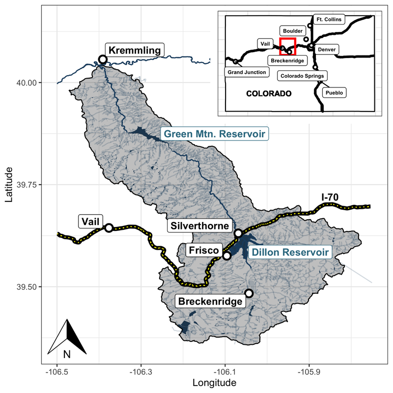
- The Blue River is located in the central Rocky Mountains, west of the Continental Divide. It drains an area of about 680 square miles covering all of Summit County and portions of Grand and Lake Counties.
- The watershed drains northward from Quandary Peak at 14,265 feet to where it flows into the Colorado River south of Kremmling at 7,400 feet.
- The Upper Blue River Watershed is formed by three major tributaries that drain into Dillon Reservoir: Snake River, Blue River, and Tenmile Creek.
- The Middle Blue River Watershed extends from Dillon Reservoir to Green Mountain Reservoir and is approximately the same size as the Upper Blue River Watershed. The Middle Blue includes portions of Ptarmigan Wilderness Area to the east and Eagles Nest Wilderness Area on the west.
- The Lower Blue River Watershed covers the outlet of Green Mountain Reservoir to the confluence with the Colorado River.
- Most of the total annual stream flow results from snow melt during the spring and early summer. The majority of snowfall typically occurs January through April. Thunderstorm activity produces significant, though short-lived, rainfall events in July and August.
- The Blue River Watershed includes all of Summit County, which encompasses approximately 619 square miles. An additional 61 square miles of the Lower Blue lie within Grand County, and the very top of the Tenmile Basin lies within Lake County.
- The major population centers within the Blue River Watershed are Blue River, Breckenridge, Copper Mountain, Frisco, Keystone, Dillon and Silverthorne. The permanent resident population of Summit County in 2010 was 27,994 and the peak seasonal population was 160,000[1]!
- Impacts from mining, large water storage projects of Dillon and Green Mountain Reservoir and Interstate 70 play a large role in the water and habitat quality throughout the watershed.

CLICK TO ENLARGE WATERSHED MAP
transbasin Diversions

Read more about Transbasins diversions
Roberts Tunnel
- Moves water from Dillon Reservoir to the South Platte Basin (Denver area)
- Largest diversion in Summit County
Straight Creek Diversion (often called the Coors Diversion)
- Diverts water from Straight Creek through the Continental Divide to the Front Range via Clear Creek. Historically associated with supplying water for brewing operations at Coors.
Vidler Tunnel
- Transfers water from Peru Creek (Snake River tributary) to the Front Range
Hoosier Pass Tunnel
- Diverts headwaters of the Blue River to the Arkansas Basin (Colorado Springs)
Boreas Pass Ditch
- Small but historic diversion from Indiana Creek to the South Platte Basin
Issues affecting the watershed
- Impacts from historical dredge boat gold mining and hard rock mining of gold, silver, lead, copper and zinc, including: loss of surface water flows during low stream flow periods, loss of channel stability, loss of aquatic and riparian habitat, and heavy metal and mineral contamination that compromises water quality.
- Deforestation and negative impacts to forest health from the mountain pine beetle epidemic resulting in increased risk of catastrophic wildfire, erosion control issues and threats of mudslides.
- Impacts from roadways including: sediment loading into streams, particularly into Straight Creek, along the I-70 corridor; chemical disbursement from routine highway operations; and hazardous material spill events which can impact both surface and ground source water.
- Impacts from invasive and non-native aquatic species, such as northern pike and brook trout, as well as preventing infestation of invasive zebra and quagga mussels.
- Loss of Gold Medal fishing status on a 19-mile stretch of the Blue River in 2016.
- Trans-mountain diversions resulting in diminished flows and reduced water availability in the Blue River Basin, reduced assimilative capacity, and impacts upon aquatic and terrestrial biota.
- Drought mitigation and the possibility for the Colorado River Compact Call
[1] Source: Summit County Government website